top of page


LiAir X4
Autonomous Flight LiDAR
Data Acquisition System
LiAir X4 is GreenValley International’s latest generation autonomous LiDAR data acquisition system. It features a lightweight 32-line rotary laser scanner, high-precision inertial navigation system, a high-resolution camera, and a powerful edge computing platform. With 360-degree scanning and the self-developed AirPilot autonomous flight algorithm, it enables efficient, safe, and cost-effective smart inspections with autonomous obstacle avoidance.
Innovative

Fully Autonomous Obstacle Avoidance Flight

5 cm Elevation Accuracy (@100 m)

300 m Maximum Measurement Range

Multi-Platform Compatibility (Airborne/Handheld)
Autonomous Flight Function

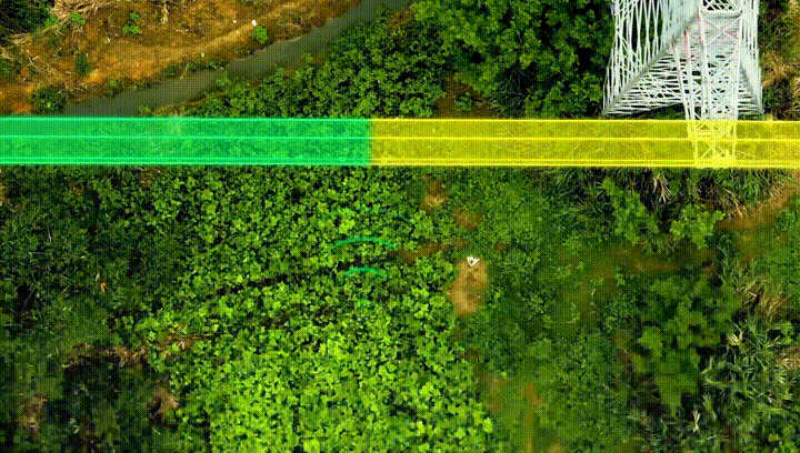
Above Powerline Following Flight
Automatic line intersection identification, autonomous crossing of intersections, real-time tree obstacle reporting and pole/tower log generation, and automated pole/tower identification and photography.
Side Powerline
Following Flight
Capture RGB photos of conductors, autonomous tower crossing and line switching.

Real-time Terrain Following Flight
Real-time DSM construction for terrain-following flight, meet the demand of large height difference terrain data collection for short-range LiDAR system.
Omni-directional
Scanning
Powered by the self-developed high-precision integrated motor, the scanner achieves 360°x270° omnidirectional scanning. Enhanced point cloud completeness in dense vegetation areas and vertical structures (buildings and bridges), with finer 3D structural reconstruction


Supports GNSS Antenna-free Solution, Simplyfying the installation process.
When mounting X4 on DJI M300/M350 RTK aircraft, there is no need to install external antennas, yet it can still acquire high-precision GNSS information. After post-processing software, a centimeter level high-precision point cloud can be generated.
GreenValley APP: New design, Focusing on Work Quality
The APP supports real-time viewing of true color point clouds and 720P/30FPS video stream. This allows the flight personnel to clearly view the surrounding environment and better evaluate the point cloud quality.


Handheld model support
-
Optional handheld kit with two configurations (Standard/Panaramic camera edition).
-
By combining GNSS and LiDAR SLAM algorithms, it enables reliable point cloud collection even in GNSS-denied environments and supports 3DGS model generation.
One device, multiple applications-maximize versatility and performance all-in-one solution.
Processing Softwares


GreenValley App
LiGeoreference
LiDAR 360 MLS
LiDAR 360

bottom of page