top of page


Rotating Handheld SLAM LiDAR System
LiGrip H120
With a variety of sensors, H120 can quickly capture a wide range of scene data, supports multi-mode operations through handheld, backpack, and vehicle-mounted platforms. In addition, it supports high-precision mapping methods such as PPK-SLAM, RTK-SLAM and pure SLAM, to quickly obtain point cloud data with absolute coordinates. Combined with LiDAR 360 and LiDAR 360MLS software, the LiGrip H300 can provide a one -stop solution on mapping, mining, forestry, road component survey and other scenarios.
Innovative
Multi-Sensor
Integrating high-performance LiDAR and panaromic cameras, it can quickly collect high precision point clouds and the image information for color rendering to the point clouds, which can truly restore multiple information on the scene.


Waterproof, Dustproof, and Shockproof
With IP54 protection, do not need to worry about dripping water and dusty environment in the roadway (tunnel).
High Compatibility
H120 supports one-stop software solutions, for data pre-processing and post-processing. The solution can be implemented conveniently.

APPLICATION SCENARIO

Topographic Mapping

Elevation Survey

Underground Surface Mapping
Topographic Mapping
1/6
Multiple Mapping Methods
.png)
RTK-SLAM
Suitable for areas with CORS signals, it allows you to directly obtain accurate point clouds with absolute coordinates.
.png)
PPK-SLAM
In areas not covered by the CORS signal, you can choose to set up a base station or use the green earth cloud trail to get a point cloud with absolute coordinates.
.png)
SLAM
Point clouds with absolute coordinates can be obtained by bringing in GCP control points (if point clouds with absolute coordinates are not required, they can be directly collected).
Multi-platform
The H120 meets the needs of different data collection scenes by supporting handheld, backpack and vehicle-mounted platforms. The operational efficiency is further enhanced.
.png)
Handheld
.png)
Backpack
.png)
Vehicle Kit
Processing Software
.png)
GreenValley App
.png)
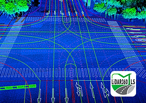
LiDAR 360
.png)
LiDAR 360 MLS

bottom of page