top of page


Rotating Handheld SLAM LiDAR System
LiGrip H300
LiGrip H300 integrates multiple high-precision mapping methods, including SLAM, PPK-SLAM, and RTK-SLAM, allowing you to swiftly acquire point cloud data with absolute coordinates. Combined with LiDAR 360 and LiDAR 360MLS software, the LiGrip H300 can provide a one -stop solution on mapping, mining, forestry, road component survey and other scenarios.
Innovative

Scan Range
up to 300 m

Laser Accuracy
up to ± 1cm
_edited.png)
Scan Rate
640,000 pts/s
_edited.png)
Multi-platform Capability
300m ranging 640,000 pts/s


1-inch CMOS camera
Supports 6K images and high performs in indoor and low-light environments
Multiple Mapping Methods
.png)
RTK-SLAM
Suitable for areas with CORS signals, it allows you to directly obtain accurate point clouds with absolute coordinates.[In some regions, this feature is not available, please consult your local sales or partners.
.png)
PPK-SLAM
Point clouds with absolute coordinates can be obtained by bringing in GCP control points (if point clouds with absolute coordinates are not required, they can be directly collected).
.png)
SLAM
Point clouds with absolute coordinates can be obtained by bringing in GCP control points (if point clouds with absolute coordinates are not required, they can be directly collected).
Multi-platform
The H300 enhances data collection flexibility and efficiency with its support for handheld, backpack, vehicle, and aerial platforms.
.png)
Airborne Mode
.png)
Backpack
.png)
Vehicle Onboard
Processing Software
.png)
GreenValley App
.png)
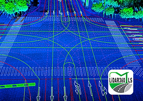
LiDAR 360
.png)
LiDAR 360 MLS

bottom of page